
This page relates to the Level 2 Strategic Flood Risk Assessment (SFRA) for Weymouth. The council is obliged to complete SFRA for its area to help guide work on local and neighbourhood plans, and decision taking on planning applications.
Purpose of SFRA
SFRA provide an overview of the risks from all sources of flooding, assessments of the cumulative impacts that development might have on flood risks and forecasts of the effects of climate change on flood risks.
Background to the Level 2 SFRA for Weymouth Town Centre
Weymouth Town Centre is particularly vulnerable to many sources of flooding because of its position at the mouth of the River Wey, coastal frontage and underlying geology. This creates significant challenges around safeguarding existing homes and businesses, as well as supporting much needed regeneration. Regeneration will be key to addressing some of the social and economic challenges which the town faces.
Alongside the council’s comprehensive flood and coastal risk management (FCRM) scheme, the SFRA provides the evidence to ensure that the risks from flooding are taken into consideration when developing proposals for the town’s regeneration. The council has and will continue to work closely with the Environment Agency, Lead Local Flood Authority and Wessex Water on both the SFRA and FCRM scheme.
The FCRM scheme to improve and replace existing flood and coastal defences is set to offer greater protection from the risks connected with flooding and coastal erosion to over 1,000 properties. The FCRM scheme, alongside measures delivered on a site by site basis as guided by the Level 2 SFRA, will provide a framework for demonstrating that new development will be safe over its lifetime and therefore support the regeneration of those town centre sites that are affected by flood risks.
Working alongside the Environment Agency the council is preparing updates to the standing advice note relating to Weymouth Town Centre. The standing advice note will outline those site-specific measures that will be necessary to ensure that development remains safe from flood risks over its lifetime. It is likely to include recommendations relating to finished floor levels (based on design flood levels) and suggestions for flood resistance and resilience measures to be incorporated into the fabric of new buildings.
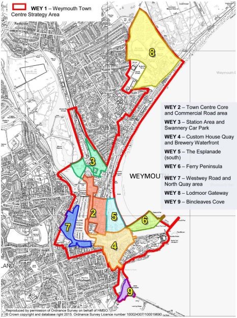
The scope of this Level 2 SFRA is limited to Weymouth Town Centre area as it is defined in the West Dorset and Weymouth & Portland Local Plan (2015) and the Weymouth Town Centre Masterplan (2015) excluding Bincleaves Cove.
The SFRA is based upon the most up to date and accurate information that is currently available. It also provides long term forecasts (to 2138) of flood risk which take account of climate change. As time passes the assessments in the SFRA will need to be reviewed and updated to reflect new evidence (including updated allowances for the impacts of climate change and new flood risk models) as our understanding of these issues changes.
Further work and ongoing review
The SFRA is an important evidence document which must be taken into consideration when preparing local and neighbourhood plans and when taking decisions on planning applications. In the short term the work on the Weymouth FCRM scheme, updates to the standing advice and more detailed site-specific Flood Risk Assessments (FEA) provide a mechanism for identifying and delivering appropriate measures to control, manage and mitigate flood risks over the lifetime of new developments connected with the town centre’s regeneration.
In the medium term the council will take account of the latest evidence on flood risk when working on its new local plan. As part of this process, it will review existing policy allocations for the town centre in the West Dorset and Weymouth and Portland Local Plan (2015), consider specific policies to control vulnerable types of development in the town centre and reserve land for flood and coastal defence infrastructure. The council will also take the requirements to control, manage and mitigate against flood risks into account when working on updates to the Weymouth Town Centre masterplan and any design coding work.
The changing nature of flood risks affecting the town centre mean that the council will need to regularly review its approach to this issue in the longer term, taking account of the nature of forecast risks and the opportunities to effectively control, manage and mitigate these risks. Further updates to the existing evidence base are likely to be required on a regular basis to guide this future work.
Level 2 SFRA reports and maps
The Level 2 SFRA was undertaken by JBA Consulting for Dorset Council. JBA Consulting prepared an overarching report entitled:
Several technical reports were also prepared to explain the parameters, data and modelling that was used to assess the flood risks from different sources of flooding.
- Surface Water model updates (June 2023)
- Weymouth Coastal model updates, Final Report (May 2023)
- Groundwater Flood Map (National) (June 2017)
Detailed flood risk maps have been prepared as part of the Level 2 SFRA for sites relating to Policies WEY2 to WEY8 of the adopted local plan. The maps show:
- fluvial flood risks and fluvial flood risks with an allowance for climate change
- surface water flood risks and surface water flood risks with an allowance for climate change
- tidal flood risks and the tidal flood risks with an allowance for climate change
- groundwater flood risks
- flood history
- defences
- modelled breach scenarios in the event that defences fail and modelled breach scenarios in the event that defences fail with an allowance for climate change
- flood warning areas
- the functional floodplain
A site ‘summary’ report has also been prepared for each policy area. These reports provide contextual site information, describe the nature of the risks from each of the different sources of flooding (fluvial, surface water, tidal and ground water), reference existing and proposed defences, describe the residual flood risks (i.e. those remaining risks after applying mitigating measures) and make recommendations as to how risks could be managed or mitigated (including minimum floor levels for proposed development).
Please follow the links for each of the town centre sites to open a separate web page showing the relevant maps and a site ‘summary’ report.
Site ‘summary’ report for policy area WEY2
WEY2 Fluvial flood risks to show:
flood depths at 0.1% (1 in 1,000), 1% (1 in 100) and 3.3% (1 in 30) AEP
flood hazard rating at 0.1% (1 in 1,000), 1% (1 in 100) and 3.3% (1 in 30) AEP
flood water velocity at 0.1% (1 in 1,000), 1% (1 in 100) and 3.3% (1 in 30) AEP
WEY2 Fluvial flood risks with an allowance for climate change to show:
flood depths at 0.1% (1 in 1,000), 1% (1 in 100) and 3.3% (1 in 30) AEP
flood hazard rating at 0.1% (1 in 1,000), 1% (1 in 100) and 3.3% (1 in 30) AEP
flood water velocity at 0.1% (1 in 1,000), 1% (1 in 100) and 3.3% (1 in 30) AEP
WEY2 Surface water flood risks
With no downstream boundary to show:
flood depths at 0.1% (1 in 1,000), 1% (1 in 100) and 3.3% (1 in 30) AEP
flood hazard rating at 0.1% (1 in 1,000), 1% (1 in 100) and 3.3% (1 in 30) AEP
flood water velocity at 0.1% (1 in 1,000), 1% (1 in 100) and 3.3% (1 in 30) AEP
Tidal downstream boundary to show:
flood depths at 0.1% (1 in 1,000), 1% (1 in 100) and 3.3% (1 in 30) AEP
flood hazard rating at 0.1% (1 in 1,000), 1% (1 in 100) and 3.3% (1 in 30) AEP
flood water velocity at 0.1% (1 in 1,000), 1% (1 in 100) and 3.3% (1 in 30) AEP
Fluvial downstream boundary to show:
flood depths at 0.1% (1 in 1,000), 1% (1 in 100) and 3.3% (1 in 30) AEP
flood hazard rating at 0.1% (1 in 1,000), 1% (1 in 100) and 3.3% (1 in 30) AEP
flood water velocity at 0.1% (1 in 1,000), 1% (1 in 100) and 3.3% (1 in 30) AEP
WEY2 Surface water flood risks with an allowance for climate change
With no downstream boundary to show:
flood depths at 0.1% (1 in 1,000), 1% (1 in 100) and 3.3% (1 in 30) AEP
flood hazard rating at 0.1% (1 in 1,000), 1% (1 in 100) and 3.3% (1 in 30) AEP
flood water velocity at 0.1% (1 in 1,000), 1% (1 in 100) and 3.3% (1 in 30) AEP
Tidal downstream boundary to show:
flood depths at 0.1% (1 in 1,000), 1% (1 in 100) and 3.3% (1 in 30) AEP
flood hazard rating at 0.1% (1 in 1,000), 1% (1 in 100) and 3.3% (1 in 30) AEP
flood water velocity at 0.1% (1 in 1,000), 1% (1 in 100) and 3.3% (1 in 30) AEP
Fluvial downstream boundary to show:
flood depths at 0.1% (1 in 1,000), 1% (1 in 100) and 3.3% (1 in 30) AEP
flood hazard rating at 0.1% (1 in 1,000), 1% (1 in 100) and 3.3% (1 in 30) AEP
flood water velocity at 0.1% (1 in 1,000), 1% (1 in 100) and 3.3% (1 in 30) AEP
WEY2 Tidal flood risks to show:
flood depths at 0.1% (1 in 1,000), 0.5% (1 in 200) and 3.3% (1 in 30) AEP
flood hazard rating at 0.1% (1 in 1,000), 0.5% (1 in 200) and 3.3% (1 in 30) AEP
flood water velocity at 0.1% (1 in 1,000), 0.5% (1 in 200) and 3.3% (1 in 30) AEP
WEY2 Tidal flood risks with an allowance for climate change to show:
flood depths at 0.1% (1 in 1,000), 0.5% (1 in 200) and 3.3% (1 in 30) AEP
flood hazard rating at 0.1% (1 in 1,000), 0.5% (1 in 200) and 3.3% (1 in 30) AEP
flood water velocity at 0.1% (1 in 1,000), 0.5% (1 in 200) and 3.3% (1 in 30) AEP
WEY2 maps to show risk of groundwater emergence:
WEY2 maps to show historic flood outlines:
WEY2 Defences:
WEY2 Modelled breach scenarios if defences fail
At Commercial Alban to show:
flood depths at 0.5% (1 in 200) and 3.3% (1 in 30) AEP
flood hazard rating at 0.5% (1 in 200) and 3.3% (1 in 30) AEP
flood water velocity at 0.5% (1 in 200) and 3.3% (1 in 30) AEP
At Westham Bridge to show:
flood depths at 0.5% (1 in 200) and 3.3% (1 in 30) AEP
flood hazard rating at 0.5% (1 in 200) and 3.3% (1 in 30) AEP
flood water velocity at 0.5% (1 in 200) and 3.3% (1 in 30) AEP
WEY2 Modelled breach scenarios (taking account of proposed defences) if defences fail with an allowance for climate change
At Commercial Alban to show:
flood depths at 0.5% (1 in 200) and 3.3% (1 in 30) AEP
flood hazard rating at 0.5% (1 in 200) and 3.3% (1 in 30) AEP
flood water velocity at 0.5% (1 in 200) and 3.3% (1 in 30) AEP
At Westham Bridge to show:
flood depths at 0.5% (1 in 200) and 3.3% (1 in 30) AEP
flood hazard rating at 0.5% (1 in 200) and 3.3% (1 in 30) AEP
flood water velocity at 0.5% (1 in 200) and 3.3% (1 in 30) AEP
WEY2 maps to show where flooding could occur and the Environment Agency provides a Flood Warning Service:
WEY2 the area where flood water has to flow or be stored during a flood:
Site ‘summary’ report for policy area WEY3
WEY3 Fluvial flood risks to show:
flood depths at 0.1% (1 in 1,000), 1% (1 in 100) and 3.3% (1 in 30) AEP
flood hazard rating at 0.1% (1 in 1,000), 1% (1 in 100) and 3.3% (1 in 30) AEP
flood water velocity at 0.1% (1 in 1,000), 1% (1 in 100) and 3.3% (1 in 30) AEP
WEY3 Fluvial flood risks with an allowance for climate change to show:
flood depths at 0.1% (1 in 1,000), 1% (1 in 100) and 3.3% (1 in 30) AEP
flood hazard rating at 0.1% (1 in 1,000), 1% (1 in 100) and 3.3% (1 in 30) AEP
flood water velocity at 0.1% (1 in 1,000), 1% (1 in 100) and 3.3% (1 in 30) AEP
WEY3 Surface water flood risks
With no downstream boundary to show:
flood depths at 0.1% (1 in 1,000), 1% (1 in 100) and 3.3% (1 in 30) AEP
flood hazard rating at 0.1% (1 in 1,000), 1% (1 in 100) and 3.3% (1 in 30) AEP
flood water velocity at 0.1% (1 in 1,000), 1% (1 in 100) and 3.3% (1 in 30) AEP
Tidal downstream boundary to show:
flood depths at 0.1% (1 in 1,000), 1% (1 in 100) and 3.3% (1 in 30) AEP
flood hazard rating at 0.1% (1 in 1,000), 1% (1 in 100) and 3.3% (1 in 30) AEP
flood water velocity at 0.1% (1 in 1,000), 1% (1 in 100) and 3.3% (1 in 30) AEP
Fluvial downstream boundary to show:
flood depths at 0.1% (1 in 1,000), 1% (1 in 100) and 3.3% (1 in 30) AEP
flood hazard rating at 0.1% (1 in 1,000), 1% (1 in 100) and 3.3% (1 in 30) AEP
flood water velocity at 0.1% (1 in 1,000), 1% (1 in 100) and 3.3% (1 in 30) AEP
WEY3 Surface water flood risks with an allowance for climate change
With no downstream boundary to show:
flood depths at 0.1% (1 in 1,000), 1% (1 in 100) and 3.3% (1 in 30) AEP
flood hazard rating at 0.1% (1 in 1,000), 1% (1 in 100) and 3.3% (1 in 30) AEP
flood water velocity at 0.1% (1 in 1,000), 1% (1 in 100) and 3.3% (1 in 30) AEP
Tidal downstream boundary to show:
flood depths at 0.1% (1 in 1,000), 1% (1 in 100) and 3.3% (1 in 30) AEP
flood hazard rating at 0.1% (1 in 1,000), 1% (1 in 100) and 3.3% (1 in 30) AEP
flood water velocity at 0.1% (1 in 1,000), 1% (1 in 100) and 3.3% (1 in 30) AEP
Fluvial downstream boundary to show:
flood depths at 0.1% (1 in 1,000), 1% (1 in 100) and 3.3% (1 in 30) AEP
flood hazard rating at 0.1% (1 in 1,000), 1% (1 in 100) and 3.3% (1 in 30) AEP
flood water velocity at 0.1% (1 in 1,000), 1% (1 in 100) and 3.3% (1 in 30) AEP
WEY3 Tidal flood risks to show:
flood depths at 0.1% (1 in 1,000), 0.5% (1 in 200) and 3.3% (1 in 30) AEP
flood hazard rating at 0.1% (1 in 1,000), 0.5% (1 in 200) and 3.3% (1 in 30) AEP
flood water velocity at 0.1% (1 in 1,000), 0.5% (1 in 200) and 3.3% (1 in 30) AEP
WEY3 Tidal flood risks with an allowance for climate change to show:
flood depths at 0.1% (1 in 1,000), 0.5% (1 in 200) and 3.3% (1 in 30) AEP
flood hazard rating at 0.1% (1 in 1,000), 0.5% (1 in 200) and 3.3% (1 in 30) AEP
flood water velocity at 0.1% (1 in 1,000), 0.5% (1 in 200) and 3.3% (1 in 30) AEP
WEY3 maps to show risk of groundwater emergence:
WEY3 maps to show historic flood outlines:
WEY3 Defences:
WEY3 Modelled breach scenarios if defences fail
At Westham Bridge to show:
flood depths at 0.5% (1 in 200) and 3.3% (1 in 30) AEP
flood hazard rating at 0.5% (1 in 200) and 3.3% (1 in 30) AEP
flood water velocity at 0.5% (1 in 200) and 3.3% (1 in 30) AEP
WEY3 Modelled breach scenarios (taking account of proposed defences) if defences fail with an allowance for climate change
At Westham Bridge to show:
flood depths at 0.5% (1 in 200) and 3.3% (1 in 30) AEP
flood hazard rating at 0.5% (1 in 200) and 3.3% (1 in 30) AEP
flood water velocity at 0.5% (1 in 200) and 3.3% (1 in 30) AEP
WEY3 maps to show where flooding could occur and the Environment Agency provides a Flood Warning Service:
WEY3 the area where flood water has to flow or be stored during a flood:
Site ‘summary’ report for policy area WEY4
WEY4 Fluvial flood risks to show:
flood depths at 0.1% (1 in 1,000), 1% (1 in 100) and 3.3% (1 in 30) AEP
flood hazard rating at 0.1% (1 in 1,000), 1% (1 in 100) and 3.3% (1 in 30) AEP
flood water velocity at 0.1% (1 in 1,000), 1% (1 in 100) and 3.3% (1 in 30) AEP
WEY4 Fluvial flood risks with an allowance for climate change to show:
flood depths at 0.1% (1 in 1,000), 1% (1 in 100) and 3.3% (1 in 30) AEP
flood hazard rating at 0.1% (1 in 1,000), 1% (1 in 100) and 3.3% (1 in 30) AEP
flood water velocity at 0.1% (1 in 1,000), 1% (1 in 100) and 3.3% (1 in 30) AEP
WEY4 Surface water flood risks
With no downstream boundary to show:
flood depths at 0.1% (1 in 1,000), 1% (1 in 100) and 3.3% (1 in 30) AEP
flood hazard rating at 0.1% (1 in 1,000), 1% (1 in 100) and 3.3% (1 in 30) AEP
flood water velocity at 0.1% (1 in 1,000), 1% (1 in 100) and 3.3% (1 in 30) AEP
Tidal downstream boundary to show:
flood depths at 0.1% (1 in 1,000), 1% (1 in 100) and 3.3% (1 in 30) AEP
flood hazard rating at 0.1% (1 in 1,000), 1% (1 in 100) and 3.3% (1 in 30) AEP
flood water velocity at 0.1% (1 in 1,000), 1% (1 in 100) and 3.3% (1 in 30) AEP
Fluvial downstream boundary to show:
flood depths at 0.1% (1 in 1,000), 1% (1 in 100) and 3.3% (1 in 30) AEP
flood hazard rating at 0.1% (1 in 1,000), 1% (1 in 100) and 3.3% (1 in 30) AEP
flood water velocity at 0.1% (1 in 1,000), 1% (1 in 100) and 3.3% (1 in 30) AEP
WEY4 Surface water flood risks with an allowance for climate change
With no downstream boundary to show:
flood depths at 0.1% (1 in 1,000), 1% (1 in 100) and 3.3% (1 in 30) AEP
flood hazard rating at 0.1% (1 in 1,000), 1% (1 in 100) and 3.3% (1 in 30) AEP
flood water velocity at 0.1% (1 in 1,000), 1% (1 in 100) and 3.3% (1 in 30) AEP
Tidal downstream boundary to show:
flood depths at 0.1% (1 in 1,000), 1% (1 in 100) and 3.3% (1 in 30) AEP
flood hazard rating at 0.1% (1 in 1,000), 1% (1 in 100) and 3.3% (1 in 30) AEP
flood water velocity at 0.1% (1 in 1,000), 1% (1 in 100) and 3.3% (1 in 30) AEP
Fluvial downstream boundary to show:
flood depths at 0.1% (1 in 1,000), 1% (1 in 100) and 3.3% (1 in 30) AEP
flood hazard rating at 0.1% (1 in 1,000), 1% (1 in 100) and 3.3% (1 in 30) AEP
flood water velocity at 0.1% (1 in 1,000), 1% (1 in 100) and 3.3% (1 in 30) AEP
WEY4 Tidal flood risks to show:
flood depths at 0.1% (1 in 1,000), 0.5% (1 in 200) and 3.3% (1 in 30) AEP
flood hazard rating at 0.1% (1 in 1,000), 0.5% (1 in 200) and 3.3% (1 in 30) AEP
flood water velocity at 0.1% (1 in 1,000), 0.5% (1 in 200) and 3.3% (1 in 30) AEP
WEY4 Tidal flood risks with an allowance for climate change to show:
flood depths at 0.1% (1 in 1,000), 0.5% (1 in 200) and 3.3% (1 in 30) AEP
flood hazard rating at 0.1% (1 in 1,000), 0.5% (1 in 200) and 3.3% (1 in 30) AEP
flood water velocity at 0.1% (1 in 1,000), 0.5% (1 in 200) and 3.3% (1 in 30) AEP
WEY4 maps to show risk of groundwater emergence:
WEY4 maps to show historic flood outlines:
WEY4 Defences:
WEY4 Modelled breach scenarios if defences fail
At Cove Row to show:
flood depths at 0.5% (1 in 200) and 3.3% (1 in 30) AEP
flood hazard rating at 0.5% (1 in 200) and 3.3% (1 in 30) AEP
flood water velocity at 0.5% (1 in 200) and 3.3% (1 in 30) AEP
At Town Bridge Downstream to show:
flood depths at 0.5% (1 in 200) and 3.3% (1 in 30) AEP
flood hazard rating at 0.5% (1 in 200) and 3.3% (1 in 30) AEP
flood water velocity at 0.5% (1 in 200) and 3.3% (1 in 30) AEP
WEY2 Modelled breach scenarios (taking account of proposed defences) if defences fail with an allowance for climate change
At Cove Row to show:
flood depths at 0.5% (1 in 200) and 3.3% (1 in 30) AEP
flood hazard rating at 0.5% (1 in 200) and 3.3% (1 in 30) AEP
flood water velocity at 0.5% (1 in 200) and 3.3% (1 in 30) AEP
At Town Bridge Downstream to show:
flood depths at 0.5% (1 in 200) and 3.3% (1 in 30) AEP
flood hazard rating at 0.5% (1 in 200) and 3.3% (1 in 30) AEP
flood water velocity at 0.5% (1 in 200) and 3.3% (1 in 30) AEP
WEY4 maps to show where flooding could occur and the Environment Agency provides a Flood Warning Service:
WEY4 the area where flood water has to flow or be stored during a flood:
Site ‘summary’ report for policy area WEY5
WEY5 Fluvial flood risks to show:
flood depths at 0.1% (1 in 1,000), 1% (1 in 100) and 3.3% (1 in 30) AEP
flood hazard rating at 0.1% (1 in 1,000), 1% (1 in 100) and 3.3% (1 in 30) AEP
flood water velocity at 0.1% (1 in 1,000), 1% (1 in 100) and 3.3% (1 in 30) AEP
WEY5 Fluvial flood risks with an allowance for climate change to show:
flood depths at 0.1% (1 in 1,000), 1% (1 in 100) and 3.3% (1 in 30) AEP
flood hazard rating at 0.1% (1 in 1,000), 1% (1 in 100) and 3.3% (1 in 30) AEP
flood water velocity at 0.1% (1 in 1,000), 1% (1 in 100) and 3.3% (1 in 30) AEP
WEY5 Surface water flood risks
With no downstream boundary to show:
flood depths at 0.1% (1 in 1,000), 1% (1 in 100) and 3.3% (1 in 30) AEP
flood hazard rating at 0.1% (1 in 1,000), 1% (1 in 100) and 3.3% (1 in 30) AEP
flood water velocity at 0.1% (1 in 1,000), 1% (1 in 100) and 3.3% (1 in 30) AEP
Tidal downstream boundary to show:
flood depths at 0.1% (1 in 1,000), 1% (1 in 100) and 3.3% (1 in 30) AEP
flood hazard rating at 0.1% (1 in 1,000), 1% (1 in 100) and 3.3% (1 in 30) AEP
flood water velocity at 0.1% (1 in 1,000), 1% (1 in 100) and 3.3% (1 in 30) AEP
Fluvial downstream boundary to show:
flood depths at 0.1% (1 in 1,000), 1% (1 in 100) and 3.3% (1 in 30) AEP
flood hazard rating at 0.1% (1 in 1,000), 1% (1 in 100) and 3.3% (1 in 30) AEP
flood water velocity at 0.1% (1 in 1,000), 1% (1 in 100) and 3.3% (1 in 30) AEP
WEY5 Surface water flood risks with an allowance for climate change
With no downstream boundary to show:
flood depths at 0.1% (1 in 1,000), 1% (1 in 100) and 3.3% (1 in 30) AEP
flood hazard rating at 0.1% (1 in 1,000), 1% (1 in 100) and 3.3% (1 in 30) AEP
flood water velocity at 0.1% (1 in 1,000), 1% (1 in 100) and 3.3% (1 in 30) AEP
Tidal downstream boundary to show:
flood depths at 0.1% (1 in 1,000), 1% (1 in 100) and 3.3% (1 in 30) AEP
flood hazard rating at 0.1% (1 in 1,000), 1% (1 in 100) and 3.3% (1 in 30) AEP
flood water velocity at 0.1% (1 in 1,000), 1% (1 in 100) and 3.3% (1 in 30) AEP
Fluvial downstream boundary to show:
flood depths at 0.1% (1 in 1,000), 1% (1 in 100) and 3.3% (1 in 30) AEP
flood hazard rating at 0.1% (1 in 1,000), 1% (1 in 100) and 3.3% (1 in 30) AEP
flood water velocity at 0.1% (1 in 1,000), 1% (1 in 100) and 3.3% (1 in 30) AEP
WEY5 Tidal flood risks to show:
flood depths at 0.1% (1 in 1,000), 0.5% (1 in 200) and 3.3% (1 in 30) AEP
flood hazard rating at 0.1% (1 in 1,000), 0.5% (1 in 200) and 3.3% (1 in 30) AEP
flood water velocity at 0.1% (1 in 1,000), 0.5% (1 in 200) and 3.3% (1 in 30) AEP
WEY5 Tidal flood risks with an allowance for climate change to show:
flood depths at 0.1% (1 in 1,000), 0.5% (1 in 200) and 3.3% (1 in 30) AEP
flood hazard rating at 0.1% (1 in 1,000), 0.5% (1 in 200) and 3.3% (1 in 30) AEP
flood water velocity at 0.1% (1 in 1,000), 0.5% (1 in 200) and 3.3% (1 in 30) AEP
WEY5 maps to show risk of groundwater emergence:
WEY5 maps to show historic flood outlines:
WEY5 Defences:
WEY5 Modelled breach scenarios if defences fail
No modelled flood extent is presented for this scenario as there is technically no raised defence along this section of shoreline. Flood levels in the modelled present day 1 in 200 year coastal flood event do not reach the level of the promenade.
WEY5 Modelled breach scenarios (taking account of proposed defences) if defences fail with an allowance for climate change
At Beach Promenade to show:
flood depths at 0.5% (1 in 200) and 3.3% (1 in 30) AEP
flood hazard rating at 0.5% (1 in 200) and 3.3% (1 in 30) AEP
flood water velocity at 0.5% (1 in 200) and 3.3% (1 in 30) AEP
WEY5 maps to show where flooding could occur and the Environment Agency provides a Flood Warning Service:
WEY5 the area where flood water has to flow or be stored during a flood:
Site ‘summary’ report for policy area WEY6
WEY6 Fluvial flood risks to show:
flood depths at 0.1% (1 in 1,000), 1% (1 in 100) and 3.3% (1 in 30) AEP
flood hazard rating at 0.1% (1 in 1,000), 1% (1 in 100) and 3.3% (1 in 30) AEP
flood water velocity at 0.1% (1 in 1,000), 1% (1 in 100) and 3.3% (1 in 30) AEP
WEY6 Fluvial flood risks with an allowance for climate change to show:
flood depths at 0.1% (1 in 1,000), 1% (1 in 100) and 3.3% (1 in 30) AEP
flood hazard rating at 0.1% (1 in 1,000), 1% (1 in 100) and 3.3% (1 in 30) AEP
flood water velocity at 0.1% (1 in 1,000), 1% (1 in 100) and 3.3% (1 in 30) AEP
WEY6 Surface water flood risks
With no downstream boundary to show:
flood depths at 0.1% (1 in 1,000), 1% (1 in 100) and 3.3% (1 in 30) AEP
flood hazard rating at 0.1% (1 in 1,000), 1% (1 in 100) and 3.3% (1 in 30) AEP
flood water velocity at 0.1% (1 in 1,000), 1% (1 in 100) and 3.3% (1 in 30) AEP
Tidal downstream boundary to show:
flood depths at 0.1% (1 in 1,000), 1% (1 in 100) and 3.3% (1 in 30) AEP
flood hazard rating at 0.1% (1 in 1,000), 1% (1 in 100) and 3.3% (1 in 30) AEP
flood water velocity at 0.1% (1 in 1,000), 1% (1 in 100) and 3.3% (1 in 30) AEP
Fluvial downstream boundary to show:
flood depths at 0.1% (1 in 1,000), 1% (1 in 100) and 3.3% (1 in 30) AEP
flood hazard rating at 0.1% (1 in 1,000), 1% (1 in 100) and 3.3% (1 in 30) AEP
flood water velocity at 0.1% (1 in 1,000), 1% (1 in 100) and 3.3% (1 in 30) AEP
WEY6 Surface water flood risks with an allowance for climate change
With no downstream boundary to show:
flood depths at 0.1% (1 in 1,000), 1% (1 in 100) and 3.3% (1 in 30) AEP
flood hazard rating at 0.1% (1 in 1,000), 1% (1 in 100) and 3.3% (1 in 30) AEP
flood water velocity at 0.1% (1 in 1,000), 1% (1 in 100) and 3.3% (1 in 30) AEP
Tidal downstream boundary to show:
flood depths at 0.1% (1 in 1,000), 1% (1 in 100) and 3.3% (1 in 30) AEP
flood hazard rating at 0.1% (1 in 1,000), 1% (1 in 100) and 3.3% (1 in 30) AEP
flood water velocity at 0.1% (1 in 1,000), 1% (1 in 100) and 3.3% (1 in 30) AEP
Fluvial downstream boundary to show:
flood depths at 0.1% (1 in 1,000), 1% (1 in 100) and 3.3% (1 in 30) AEP
flood hazard rating at 0.1% (1 in 1,000), 1% (1 in 100) and 3.3% (1 in 30) AEP
flood water velocity at 0.1% (1 in 1,000), 1% (1 in 100) and 3.3% (1 in 30) AEP
WEY6 Tidal flood risks to show:
flood depths at 0.1% (1 in 1,000), 0.5% (1 in 200) and 3.3% (1 in 30) AEP
flood hazard rating at 0.1% (1 in 1,000), 0.5% (1 in 200) and 3.3% (1 in 30) AEP
flood water velocity at 0.1% (1 in 1,000), 0.5% (1 in 200) and 3.3% (1 in 30) AEP
WEY6 Tidal flood risks with an allowance for climate change to show:
flood depths at 0.1% (1 in 1,000), 0.5% (1 in 200) and 3.3% (1 in 30) AEP
flood hazard rating at 0.1% (1 in 1,000), 0.5% (1 in 200) and 3.3% (1 in 30) AEP
flood water velocity at 0.1% (1 in 1,000), 0.5% (1 in 200) and 3.3% (1 in 30) AEP
WEY6 maps to show risk of groundwater emergence:
WEY6 maps to show historic flood outlines:
WEY6 Defences:
WEY6 Modelled breach scenarios if defences fail
At Ferry Terminal to show:
flood depths at 0.5% (1 in 200) and 3.3% (1 in 30) AEP
flood hazard rating at 0.5% (1 in 200) and 3.3% (1 in 30) AEP
flood water velocity at 0.5% (1 in 200) and 3.3% (1 in 30) AEP
WEY6 Modelled breach scenarios (taking account of proposed defences) if defences fail with an allowance for climate change
At Ferry Terminal to show:
flood depths at 0.5% (1 in 200) and 3.3% (1 in 30) AEP
flood hazard rating at 0.5% (1 in 200) and 3.3% (1 in 30) AEP
flood water velocity at 0.5% (1 in 200) and 3.3% (1 in 30) AEP
WEY6 maps to show where flooding could occur and the Environment Agency provides a Flood Warning Service:
WEY6 the area where flood water has to flow or be stored during a flood:
Site ‘summary’ report for policy area WEY7
WEY7 Fluvial flood risks to show:
flood depths at 0.1% (1 in 1,000), 1% (1 in 100) and 3.3% (1 in 30) AEP
flood hazard rating at 0.1% (1 in 1,000), 1% (1 in 100) and 3.3% (1 in 30) AEP
flood water velocity at 0.1% (1 in 1,000), 1% (1 in 100) and 3.3% (1 in 30) AEP
WEY7 Fluvial flood risks with an allowance for climate change to show:
flood depths at 0.1% (1 in 1,000), 1% (1 in 100) and 3.3% (1 in 30) AEP
flood hazard rating at 0.1% (1 in 1,000), 1% (1 in 100) and 3.3% (1 in 30) AEP
flood water velocity at 0.1% (1 in 1,000), 1% (1 in 100) and 3.3% (1 in 30) AEP
WEY7 Surface water flood risks
With no downstream boundary to show:
flood depths at 0.1% (1 in 1,000), 1% (1 in 100) and 3.3% (1 in 30) AEP
flood hazard rating at 0.1% (1 in 1,000), 1% (1 in 100) and 3.3% (1 in 30) AEP
flood water velocity at 0.1% (1 in 1,000), 1% (1 in 100) and 3.3% (1 in 30) AEP
Tidal downstream boundary to show:
flood depths at 0.1% (1 in 1,000), 1% (1 in 100) and 3.3% (1 in 30) AEP
flood hazard rating at 0.1% (1 in 1,000), 1% (1 in 100) and 3.3% (1 in 30) AEP
flood water velocity at 0.1% (1 in 1,000), 1% (1 in 100) and 3.3% (1 in 30) AEP
Fluvial downstream boundary to show:
flood depths at 0.1% (1 in 1,000), 1% (1 in 100) and 3.3% (1 in 30) AEP
flood hazard rating at 0.1% (1 in 1,000), 1% (1 in 100) and 3.3% (1 in 30) AEP
flood water velocity at 0.1% (1 in 1,000), 1% (1 in 100) and 3.3% (1 in 30) AEP
WEY7 Surface water flood risks with an allowance for climate change
With no downstream boundary to show:
flood depths at 0.1% (1 in 1,000), 1% (1 in 100) and 3.3% (1 in 30) AEP
flood hazard rating at 0.1% (1 in 1,000), 1% (1 in 100) and 3.3% (1 in 30) AEP
flood water velocity at 0.1% (1 in 1,000), 1% (1 in 100) and 3.3% (1 in 30) AEP
Tidal downstream boundary to show:
flood depths at 0.1% (1 in 1,000), 1% (1 in 100) and 3.3% (1 in 30) AEP
flood hazard rating at 0.1% (1 in 1,000), 1% (1 in 100) and 3.3% (1 in 30) AEP
flood water velocity at 0.1% (1 in 1,000), 1% (1 in 100) and 3.3% (1 in 30) AEP
Fluvial downstream boundary to show:
flood depths at 0.1% (1 in 1,000), 1% (1 in 100) and 3.3% (1 in 30) AEP
flood hazard rating at 0.1% (1 in 1,000), 1% (1 in 100) and 3.3% (1 in 30) AEP
flood water velocity at 0.1% (1 in 1,000), 1% (1 in 100) and 3.3% (1 in 30) AEP
WEY7 Tidal flood risks to show:
flood depths at 0.1% (1 in 1,000), 0.5% (1 in 200) and 3.3% (1 in 30) AEP
flood hazard rating at 0.1% (1 in 1,000), 0.5% (1 in 200) and 3.3% (1 in 30) AEP
flood water velocity at 0.1% (1 in 1,000), 0.5% (1 in 200) and 3.3% (1 in 30) AEP
WEY7 Tidal flood risks with an allowance for climate change to show:
flood depths at 0.1% (1 in 1,000), 0.5% (1 in 200) and 3.3% (1 in 30) AEP
flood hazard rating at 0.1% (1 in 1,000), 0.5% (1 in 200) and 3.3% (1 in 30) AEP
flood water velocity at 0.1% (1 in 1,000), 0.5% (1 in 200) and 3.3% (1 in 30) AEP
WEY7 maps to show risk of groundwater emergence:
WEY7 maps to show historic flood outlines:
WEY7 Defences:
WEY7 Modelled breach scenarios if defences fail
At Westway Road to show:
flood depths at 0.5% (1 in 200) and 3.3% (1 in 30) AEP
flood hazard rating at 0.5% (1 in 200) and 3.3% (1 in 30) AEP
flood water velocity at 0.5% (1 in 200) and 3.3% (1 in 30) AEP
WEY7 Modelled breach scenarios (taking account of proposed defences) if defences fail with an allowance for climate change
At Westway Road to show:
flood depths at 0.5% (1 in 200) and 3.3% (1 in 30) AEP
flood hazard rating at 0.5% (1 in 200) and 3.3% (1 in 30) AEP
flood water velocity at 0.5% (1 in 200) and 3.3% (1 in 30) AEP
WEY7 maps to show where flooding could occur and the Environment Agency provides a Flood Warning Service:
WEY7 the area where flood water has to flow or be stored during a flood:
Site ‘summary’ report for policy area WEY8
WEY8 Fluvial flood risks to show:
flood depths at 0.1% (1 in 1,000), 1% (1 in 100) and 3.3% (1 in 30) AEP
flood hazard rating at 0.1% (1 in 1,000), 1% (1 in 100) and 3.3% (1 in 30) AEP
flood water velocity at 0.1% (1 in 1,000), 1% (1 in 100) and 3.3% (1 in 30) AEP
WEY8 Fluvial flood risks with an allowance for climate change to show:
flood depths at 0.1% (1 in 1,000), 1% (1 in 100) and 3.3% (1 in 30) AEP
flood hazard rating at 0.1% (1 in 1,000), 1% (1 in 100) and 3.3% (1 in 30) AEP
flood water velocity at 0.1% (1 in 1,000), 1% (1 in 100) and 3.3% (1 in 30) AEP
WEY8 Surface water flood risks
With no downstream boundary to show:
flood depths at 0.1% (1 in 1,000), 1% (1 in 100) and 3.3% (1 in 30) AEP
flood hazard rating at 0.1% (1 in 1,000), 1% (1 in 100) and 3.3% (1 in 30) AEP
flood water velocity at 0.1% (1 in 1,000), 1% (1 in 100) and 3.3% (1 in 30) AEP
Tidal downstream boundary to show:
flood depths at 0.1% (1 in 1,000), 1% (1 in 100) and 3.3% (1 in 30) AEP
flood hazard rating at 0.1% (1 in 1,000), 1% (1 in 100) and 3.3% (1 in 30) AEP
flood water velocity at 0.1% (1 in 1,000), 1% (1 in 100) and 3.3% (1 in 30) AEP
Fluvial downstream boundary to show:
flood depths at 0.1% (1 in 1,000), 1% (1 in 100) and 3.3% (1 in 30) AEP
flood hazard rating at 0.1% (1 in 1,000), 1% (1 in 100) and 3.3% (1 in 30) AEP
flood water velocity at 0.1% (1 in 1,000), 1% (1 in 100) and 3.3% (1 in 30) AEP
WEY8 Surface water flood risks with an allowance for climate change
With no downstream boundary to show:
flood depths at 0.1% (1 in 1,000), 1% (1 in 100) and 3.3% (1 in 30) AEP
flood hazard rating at 0.1% (1 in 1,000), 1% (1 in 100) and 3.3% (1 in 30) AEP
flood water velocity at 0.1% (1 in 1,000), 1% (1 in 100) and 3.3% (1 in 30) AEP
Tidal downstream boundary to show:
flood depths at 0.1% (1 in 1,000), 1% (1 in 100) and 3.3% (1 in 30) AEP
flood hazard rating at 0.1% (1 in 1,000), 1% (1 in 100) and 3.3% (1 in 30) AEP
flood water velocity at 0.1% (1 in 1,000), 1% (1 in 100) and 3.3% (1 in 30) AEP
Fluvial downstream boundary to show:
flood depths at 0.1% (1 in 1,000), 1% (1 in 100) and 3.3% (1 in 30) AEP
flood hazard rating at 0.1% (1 in 1,000), 1% (1 in 100) and 3.3% (1 in 30) AEP
flood water velocity at 0.1% (1 in 1,000), 1% (1 in 100) and 3.3% (1 in 30) AEP
WEY8 Tidal flood risks to show:
flood depths at 0.1% (1 in 1,000), 0.5% (1 in 200) and 3.3% (1 in 30) AEP
flood hazard rating at 0.1% (1 in 1,000), 0.5% (1 in 200) and 3.3% (1 in 30) AEP
flood water velocity at 0.1% (1 in 1,000), 0.5% (1 in 200) and 3.3% (1 in 30) AEP
WEY8 Tidal flood risks with an allowance for climate change to show:
flood depths at 0.1% (1 in 1,000), 0.5% (1 in 200) and 3.3% (1 in 30) AEP
flood hazard rating at 0.1% (1 in 1,000), 0.5% (1 in 200) and 3.3% (1 in 30) AEP
flood water velocity at 0.1% (1 in 1,000), 0.5% (1 in 200) and 3.3% (1 in 30) AEP
WEY8 maps to show risk of groundwater emergence:
WEY8 maps to show historic flood outlines:
WEY8 Defences:
WEY8 Modelled breach scenarios if defences fail
At Lodmoor Nature to show:
flood depths at 0.5% (1 in 200) and 3.3% (1 in 30) AEP
flood hazard rating at 0.5% (1 in 200) and 3.3% (1 in 30) AEP
flood water velocity at 0.5% (1 in 200) and 3.3% (1 in 30) AEP
WEY8 Modelled breach scenarios (taking account of proposed defences) if defences fail with an allowance for climate change
At Lodmoor Nature to show:
flood depths at 0.5% (1 in 200) and 3.3% (1 in 30) AEP
flood hazard rating at 0.5% (1 in 200) and 3.3% (1 in 30) AEP
flood water velocity at 0.5% (1 in 200) and 3.3% (1 in 30) AEP