
Geology dominates the landscape, wildlife and local character of Dorset. From clay vales, limestone scarps, chalk downland to sandy heaths and even ancient landslides and erosion surfaces, a great diversity of rock types, erosional processes and structures have created the unique, variable and distinctive countryside. This ‘geodiversity’ underpins the biodiversity of the county from chalk downland to limestone grassland, heathlands, wet flushes and vegetated sea cliffs, it is the range of rock types and erosional forces acting on them that have created the habitats for the county’s celebrated wildlife.
Man has made use of the geology; particularly the local building stones and mineral resources. The character of the picturesque towns, villages and, in places, dry stone walls, is due to the use of a diverse range of local building stones. Aggregate, sands, gravels, clays and oil are all important economic resources to the county and are obviously based on the underlying and geological resource.
The clear relationship between geology, topography and landscape character is seen in the following diagrams.
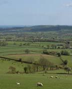
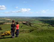
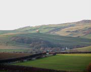
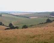
The central parts of Dorset are dominated by an extensive swathe of chalk running North East to South West and through the South of the County round Weymouth to Purbeck. It extends North East towards Salisbury Plain in Wiltshire. It is an elevated, spacious landscape with a prominent escarpment which dominates and defines the undulating farmlands to the North, West and South of the county. There are some distinctive highpoints along the escarpment such as Melbury Hill, Bulbarrow, Hod, Hambledon and Eggardon Hills. The shallow dip slope of the chalk borders the heathland landscapes of the Poole Basin. This undulating lowland contains the remnants of a once extensive area of heathland; Hardy’s Egdon Heath and is based on thin and impoverished sands and gravels. It is drained by the alluvial basins of the Frome, Piddle, Stour and Avon, four of Dorset’s main rivers which flow out to sea through extensive stretches of pasture, marsh and mudflats associated with Poole and Christchurch harbours.
To the north of the chalk escarpment, the Blackmore Vale is an extensive, flat clay vale bordered by limestone ridges to the North West and deeply undulating foothills beside the escarpment to the south and east of the vale. The vale is drained by the alluvial basin of the Stour and its tributaries the River Lydden and the Caundle Brook. To the West of the county the landscape is more varied reflecting the complex geology, with steep distinctive greensand ridges separating clusters of deeply incised valleys and broad rolling farmland. In the middle of West Dorset, the Marshwood Vale, formed on the marls of the Lower Lias, is a secluded, bowl shaped depression, almost hidden by the surrounding complex landforms. These landforms include the broad arc of heathy greensand ridges and some of the highest points in the county such as Pilsden Pen and Lewesdon Hill, the highest at 915 feet, are found here. These undulating greensand ridges are outliers of the Blackdown Hills to the east in Devon and this landscape continues south up to the cliffs where it is truncated abruptly by the sea and down into the rolling landscape of the Axe valley to the north.
The lowlands to the West and east of Weymouth are different again to the West Dorset landscapes. A series of broad, hogback shaped limestone ridges alternate with spacious shallow clay valleys. The landforms all follow an east-West alignment and the landscape has a steady consistent rhythm. This ‘ridge and vale’ landscape flows down to the quiet edges of the brackish Fleet lagoon contrasting with the more exposed seaward side of this distinctive feature which is separated from the sea by the sweep of Chesil Beach. This distinctive shingle bank links the rocky limestone peninsula of Portland to the mainland.
The far South eastern corner of the county has a unique and remarkable geological context. The Isle of Purbeck is renowned for the variety and structural clarity of its rocks and landforms. A high chalk ridge, which once linked Purbeck to the Isle of Wight, separates the heathlands of the Poole Basin from the secluded clay valley of the River Corfe to the South. A further ridge and distinctive plateau, this time of limestone, separates this valley from the sea.
The sequence of cliff and bays along the 87 miles of Dorset’s coast clearly reveal the complex geological structure of the landscape inland. The rocks have been carved by the powerful forces of coastal erosion and deposition leaving a legacy of unique features like Lulworth Cove, Durdle Door, Chesil Beach, the under cliffs and landslips around Charmouth and the beaches of Poole and Bournemouth. The resistant headlands along the coast form distinctive landmarks, with Golden Cap at 626 feet being the highest point along the entire South coast.
Other features represent remnants of previous coastal processes, indicating the long history of physical landscape evolution. An example of this, mentioned above, is when the sea rose following the ice age leading to the severance of the chalk ridge joining the Isle of Purbeck to the Isle of Wight and the flooding of the upper reaches of the Solent River to form Poole harbour. The chalk stacks of Old Harry Rocks to the East of Ballard Point are the remnants of former chalk ridge which linked the Isle of Wight.
The geo-diversity of Dorset is expressed in both the landscape and the quarries opened up for building stone and other mineral resources. However, the use of local stone has greatly declined over the last one hundred years and geo-diversity has suffered as a result. Many old quarry sites have become overgrown or filled in. Some quarries are designated as Sites of Special Scientific Interest or Regionally Important Geological/Geomorphological Sites (RIGS) but without management they will continue to decline. The loss of local quarries also impacts on the built environment as local stone is no longer available. As a result Purbeck Stone or Ham Stone are typically substituted. The use of artificial stone further weakens the character and local distinctiveness of the built environment.
The loss of geo-diversity is, without doubt, the greatest issue for geology across the Dorset countryside but it could be different. Greater use of local stone could maintain the character of towns and villages and create geo-diversity. On the other hand, in landscape and visual terms, quarrying can be damaging. Is quarrying in Purbeck part of the landscape or damaging to the landscape? What does it do for local character and the economy? Clearly a balance has to be struck but across large parts of Dorset, local stone is no longer available, with a direct impact on the quality of new buildings and the character of the built environment.
Key geological features
- it would be impossible to examine all of the rock types and their expression on the landscape and the built environment and therefore the following attempts to describe only the most prominent or striking examples
Clay Vales and Limestone Escarpments
The softer clays form vales and are often surrounded by escarpments formed from harder rocks. The Marshwood Vale is formed from a huge dome shaped fold in Lower Jurassic aged clays, the rocks that are seen on the coast between Lyme Regis and Seatown. The surrounding hills of Lamberts Castle, Pilsdon Pen and Lewesdon Hill, with Hardown Hill to the south, are remnants of an overlying layer of Cretaceous aged Upper Greensand and the change in geology is often marked by a change in slope and vegetation. The Upper Greensand is well drained and the soils are thin and leaches, supporting heathland vegetation.
The valley of Portesham through to the lowlands behind Weymouth is formed from the erosion of softer Kimmeridge Clay. To the North, hard Portland Limestone and Purbeck Beds form the Weymouth Ridgeway and these have been quarried for local stone and dry stone walling. Between Worbarrow Bay and Swanage Bay, the Wealden Clay gives rise to a valley enclosed by Purbeck limestone to the south and the Chalk to the north, which has been folded into a near vertical orientation. The River Hooke has cut its valley into Middle Jurassic aged Fullers Earth which also gives rise to the wet, boggy fields on the south side of the valley at Kingcombe. To the north the overlying Chalk downland creates a dramatic contrast to the low-lying valleys.
Deep valleys and sunken lanes
The soft Lower Jurassic Bridport Sand gives rise to a distinctive landscape of steep, V shaped valleys and sunken lanes, around Loders, Mapperton and Powerstock, near Bridport and Northwards to the Yeovil area. A thin band of hard Inferior Oolite limestone caps the soft sand and this often forms flat, tabular hill tops.
The Chalk Escarpment
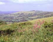
The Upper Greens and and Chalk lie on an eroded surface of older Lower Cretaceous or Jurassic rocks and this gives rise to a striking change in landscape character, usually from clay vales to steep slopes leading up onto the Chalk plateau often dissected by steep dry valleys. Although the Chalk is not hard, it is a massive rock that has resisted the forces of weathering over millions of years. The edge of the plateau forms striking features such as Eggerdon Hill and Fontmell Down are classic examples.
The Chalk Downs
Chalk is the thickest single geological unit in the county and possibly the most extensive and easily recognised rock in England. It forms extensive downs cut by dry valleys. Cranborne Chase leading onto Salisbury Plain is all formed by Chalk.
The Tertiary Heaths
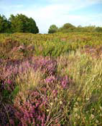
The Tertiary sands, gravels and clays in the East of the County give rise to heathland. Sands and gravels form dry, leached soils that support the heath while clays form boggy areas.
The Tertiary pediplane
Virtually all the hills in West Dorset and East Devon are flat topped and the same height. The flat surface is the remains of an ancient Tertiary (40 million years) land surface. The rocks were raised up and planed away by erosion. Later the rivers cut into this land surface leaving remnants of the plateau- the flat topped hills.
The Weymouth Anticline
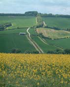
The area North and West of Weymouth lies within a huge anticline or dome shaped structure. The rocks rise out of the sea in the south, forming the wedge shape of Portland, and dive back into the landscape to the north. The result is a series of parallel limestone hills and clay vales that run east to west from the shores of the Fleet to Osmington.
The Purbeck Monocline – Corfe Castle
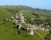
Across Purbeck, from Durdle Door to Ballard Down, the rocks have been heaved up by Earth movements into a huge kink. Either side of the fold the rocks are virtually horizontal but within it, they are vertical. Where the Chalk is caught up in this fold, it forms the ridgeway extending from Lulworth to Ballard Down and out across to The Needles on the Isle of Wight. In places rivers have breached the ridgeway, making an ideal location for a defensive structure such as Corfe Castle.
Ancient Landslides
During the last Ice Age, areas such as the Marshwood Vale or the slopes either side of Abbotsbury hill would have looked similar to the coastal cliffs with landslides cutting into the hilltops and mudslides extending into the valleys. With the onset of less harsh weathering, these landslides have reached a stable angle but the bumpy ground and crescent shaped scars extending into the hill tops can still clearly be seen. These ancient landslide slopes can be seen around the edge of the Marshwood Vale (Sliding Hill at Bettiscombe is a good example), on the western side of Quarr Hill, Chideock below the Bellstone on Eggerdon and both sides of Abbotsbury Hill Fort.
Dry Valleys – the Chalk
Dry valleys are a feature of the Chalk plateau. Chalk is permeable and water normally sinks through it so how did the valleys form? During the last Ice Age, the ground was permanently frozen but the winter snow melted in the summer, flowing over the hard, perma-frost and eroding the valleys.
The Valley of the Rocks is a particularly unusual example where the top of the slope was originally capped by Tertiary pebbles (conglomerate) that have been cemented together to form ‘Puddingstone’. Frost action during the Ice Age slowly forced these massive rocks down the slope to the bottom of the valley where they lie today. Similar rocks can be seen in the stream next to the church at Portesham.