Clay valley


Location
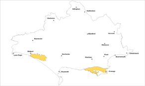
The Clay Valley landscape type is found in two locations on the Isle of Purbeck; in the Corfe valley and in the sweeping landscapes of the Kimmeridge Coast. It is also found in the broad Bride Valley east of Burton Bradstock.
Key Characteristics
- varied landform from broad open valley, to more sweeping valley and areas which are more secluded.
- enclosed and defined by dramatic steep chalk and limestone escarpments and ridges.
- patchwork of small scale pasture, irregular dense hedges and copses with larger arable fields, grassland and scrub on the steeper slopes.
- small, nucleated and scattered villages and farmsteads.
- distinctive church towers act as local landmarks.
- occasional small wet woods, springs and flushes on valley floors.
- larger scale woods on valley sides.
- winding rural lanes with mixed boundaries from stone walls to hedgebanks.
- distinctive coastal landmarks and features.
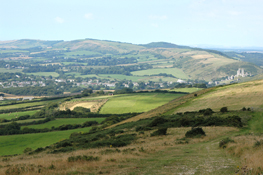
Each of the three areas of the Clay Valley landscape type has its own unique identity. The surrounding dramatic escarpments and ridges enclose and define these valley landscapes with the Purbeck chalk ridge in particular forming an imposing backdrop to the Corfe valley. The areas generally have a settled rural character with an intimate secluded feel in places and nearer the coast a more windswept, remote and exposed character. There are some dramatic and distinctive coastal landmarks and features. The patchwork of generally small scale rolling pastures, dense hedgerows, scattered woodlands and scrub on steeper slopes, have been shaped by centuries of woodland clearance and agricultural improvement. There are occasional small wet woods and springs and flushes on the valley floors with larger woods on the valley sides and from the elevated areas glimpses of the sea. The winding rural lanes have mixed boundaries including old stonewalls and hedgebanks with the stone walls more noticeable nearer the Purbeck plateau. The small farmsteads and nucleated picturesque villages such as at Swyre, Puncknowle, Litton Cheney and Burton Bradstock are often hidden and dotted throughout the landscape. The church towers at Steeple, Church Knowle and Kingston are particularly prominent landscape features with the views over the valley to Corfe Castle from Kingston being one of the distinctive panoramas in the area. The hard western edges of Swanage and to a lesser extent the eastern edges of Bridport, detract from the character of the area. The popular and distinctive ruined castle and village at Corfe Castle, the historic folly of Clavell’s Tower and the prominent landmarks of Swyre Head and Worbarrow Tout are all key landmarks in the area. Several of the planned parkland landscapes across the area are also key features.
Management Objectives
The overall management objective for the Clay Valley Landscape Type is to conserve and restore the intimate patterns of grasslands, woodlands, field boundaries and nucleated settlements.
Key land management guidance notes
- restore and enhance the condition of existing small broadleaved woodlands.
- consider extending wet woodland on the valley floor, particularly around existing settlements and farmsteads.
- encourage low impact grazing and conservation of permanent pastures including calcareous grassland and wet grasslands to protect wildlife and historic features.
- encourage maintenance and restoration of boundaries, particularly dense hedgerows and banks along the valley floors and stonewalls towards the higher ground.
- the development of scrub may be encouraged as it provides important habitat in areas where the establishment of trees is affected by coastal climate
- encourage grazing on the chalk and limestone ridges to manage scrub encroachment on important grasslands.
- maintain and enhance the sweeping views of the coast.
- seek opportunities to establish small-scale broadleaved native planting around existing settlements and farmsteads to reduce the visual impact of existing intrusive developments.
- conserve the pattern of tight knit nucleated villages and the use of local limestone for new build and/or restoration work.
- conserve views of key landmarks such as church spires e.g. through the careful control of building heights.
- conserve the intimate character of rural lanes and open character towards the coast e.g. by the careful consideration of new development design, positioning and height.
- reduce the impact of car parks and other visitor based development e.g. through sensitive signage and improved management of built features such as walls and other boundaries.
