Chalk valley & downland


Location
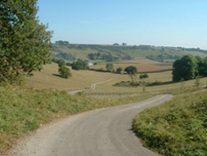
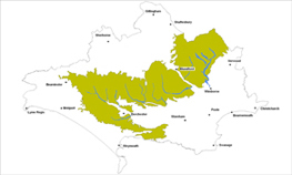
The Chalk Valley and Downland landscape type is found in a broad belt running across the county between the heathland basin to the southeast and the vale landscapes to the northwest, forming part of the wider chalk landscape of Wessex.
Key Characteristics
- extensive and uniform area of chalk covering a large part of the county.
- visually dominant with open views from expansive elevated areas.
- smaller scale pattern of fields and winding ribbons of trees along the valley floors creates a more sheltered and secluded character.
- distinctive north south aligned valleys each with its own unique character.
- chalk streams, semi natural chalk grasslands and ancient woodland are all key habitats.
- large arable fields subdivided by low, thin and straight hedges.
- historic now disused water meadows are key features.
- distinctive settlements of stone, brick and flint in linear form along the valley floors.
- roads typically follow valley floors or on elevated ridges along old straight Roman alignments.
- important old boundary features such as railings and walls.
The Chalk Valley and Downland landscape type has a dominant visual influence being more extensive and generally more elevated than other landscape types in the county with open views from elevated positions. The whole area is undulating with an inverted saucer shaped profile and a gentle dip slope towards the Frome valley and Poole Basin linking into the escarpment landscape along its remaining edges. The distinctive north south aligned, secluded chalk valleys of this landscape drain and subdivide the surrounding chalk downlands. Flowing southwards into the larger Stour, Piddle and Stour rivers, each valley has its own unique character and sense of place, with a diversity of important habitats and cultural features. The chalk streams themselves are key habitats as well as significant landscape and cultural features.
Management Objectives
The overall management objective for the Chalk Valley and Downland Landscape Type should be to conserve the strong settlement pattern, whilst restoring woodlands and meadows, chalk grasslands and important boundary features.
Key land management guidance notes
- conserve and/or restore all chalk streams, and not just the winterbournes, and their associated habitats and features of cultural interest. Ensure over abstraction does not impact on river flows.
- encourage opportunities for enhanced woodland management on the valley sides, especially coppice management.
- where important grasslands and views will not be affected, promote the planting of small oak, ash and hazel broadleaved woodlands on gentle slopes and around settlements and farmsteads to increase landscape diversity.
- new coniferous planting and shelterbelts should not be encouraged.
- enhance management of existing chalk grasslands and, where important woodland edges will not be affected (along the valley floor and settlements), encourage reversion back to chalk grassland where remaining areas could be linked up.
- plant new parkland trees (and retain veteran trees for wildlife purposes) and replant new areas of wet woodland along the river valleys.
- conserve and restore remnant water meadow systems that are an important historic landscape feature and provide opportunities for supporting traditional land management practices.
- encourage the maintenance and replacement of important boundaries, particularly parkland railings and flint walls, along the valley floors.
- conserve and enhance the pattern and character of valley floor ‘ribbon development’ villages.
- identify, protect and conserve views of key landmarks e.g. via Parish Action Plans, Village Design Statements and other Settlement Appraisals.
