Chalk ridge / escarpment


Location
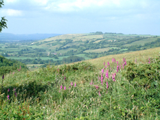
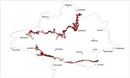
The Chalk Escarpment/Ridge landscape type defines the furthest extent of the chalk landscapes of the county around its north, west and southern outer margins.
Key Characteristics
- steep, distinctive and bold ridge and scarp slope on the edges of the chalk landscapes.
- dramatic visual edge enclosing and providing a backdrop to the surrounding countryside.
- marked variation in character and landform along the scarp.
- undeveloped and open character with panoramic views.
- distinctive and bold pattern of land cover including hanging mixed woods and patches of chalk grassland.
- woodlands are often visually prominent landmarks.
- settlements concentrated along the foot of the scarp.
- narrow twisting lanes often with high hedgebanks.
- many ancient and distinctive hillforts on escarpment highpoints such as Eggarden and Hod/Hambledon Hills.
The Chalk Escarpment/Ridge landscape forms a steep, distinctive and dramatic backdrop to, and gives panoramic views of, much of the surrounding patchwork lowland landscape. It is a bold, dominant and prominent visual edge which helps enclose the surrounding landscapes. Although in geological terms an escarpment is slightly different to a ridge, they have been grouped together for this assessment as they share very similar characteristics and management requirements. However the northern, western and southern sections do have variations in character and landform often based on geology and patterns of erosion. With an undeveloped, open character and bold skyline, this landscape type supports important patches of chalk grassland and hanging mixed woodlands which together often form broad distinctive patterns and adds variety along the steep scarp slopes. The woods are often very visible landmarks. In many locations the small scale pattern of fields extends up the scarp slopes from the valleys below gradually giving way to larger fields or open downland. Settlements such as Compton Abbas, Durweston, Ibberton, Litton Cheney and Askerswell are concentrated at the foot of slopes, along the spring line and apart from these, which are on the fringes of the area, there are only a few scattered farms. The network of narrow, steep and twisting lanes often have high hedge banks which create ‘tunnels’ before emerging on the ridgetops. There are many ancient hillforts several of which are key landmarks, including Fontmell Down and Melbury, Hod, Hambledon, Eggarden and Bulbarrow Hills. These dramatic landscapes have been captured by the romantic paintings and writings of Wilsdon Steer, Moffat Linder, Daniel Defoe and Lamora Birch.
Management Objectives
The overall management objective for the Chalk Escarpment Landscape Type should be to conserve the uninterrupted landform, strong open skyline and the distinct mosaic patterning of woodland, scrub and chalk grassland and to seek opportunities to restore and enhance habitats and historic features.
Key land management guidance notes
- promote the use of visually permeable boundaries such as post and wire fencing on higher ground and enhance the sense of continuity and openness across the escarpment/ridge tops and associated monuments.
- monitor continued encroachment of scrub on the steepest slopes. Manage scrub as a valued habitat component, and encourage grazing where appropriate and avoid cutting vegetation in straight lines to minimise visual impact. Retain occasional small patches of scrub for aesthetic and wildlife benefits.
- seek opportunities to recreate, link and restore important grassland sites and buffer from intensive management
- further woodland planting is not a key objective for this area, with the aim being to maintain the balance of open land and woodland cover with enhanced woodland management.
- ensure conservation and restoration of low impact grassland management around prehistoric features, particularly barrows and hill forts.
- promote sustainable management and recreational access to Open Access areas and important viewpoints.
- consider location of game cover crops in visible locations to minimise visual impact.
- maintain the undeveloped character of the scarp and the sharp contrast with the scarp foot settlements e.g. by the careful control of settlement edges and boundaries.
- any new development should be small scale and should respect the distinctive nucleated ‘scarp foot’ settlement pattern and should not extend onto the lower slopes.
- conserve the rural character of the narrow sunken lanes and protect sensitive hedgebanks from further erosion e.g. by identification of key sites through Parish Action Plans or similar and/or via Conservation Verge ‘designation’.
- identify, protect and enhance important views to and from the ridge/escarpment e.g. via Parish Action Plans, Village Design Statements and other Settlement Appraisals.
