Heath / forest mosaic
Location
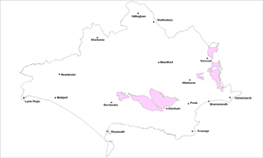
The Forest Heath landscape type forms part of the wider ‘Poole Basin’, an extensive and expansive area of former heathland on acidic and impoverished soils.
Key Characteristics
- an extensive and expansive landscape with an unspoilt feel over a
large proportion
- a mosaic of heath, forest and scrub on impoverished sandy soils
- extensive stands of conifer plantation on former heathland sites
- varied landform but generally on elevated areas subdivided by a
series of river valleys
- forms a ‘buffer’ between the chalk landscapes, river valleys and
other heathland landscape types
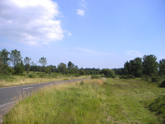
- straight roads lined by woodland/forest/grass/scrub mosaic
- significant impacts created by urban development such as
industrial, military use, quarrying, housing and transport corridors
- important open vistas from key viewpoints
- area popular for informal recreation activities as well as for
nature conservation
The Heath/Forest Mosaic type is a transitional area between the chalk
landscapes, river valleys and other heathland landscape types and in
the east extends over the border into Hampshire. It has a varied
landform from undulating in the west with steeper slopes in the east
of the county. It is generally formed on elevated plateaus or ridges
cut by the rivers Avon, Moors, Sherford, Piddle and Frome. It is
characterised by a patchwork landscape of heath, forest and scrub on
sandy soil with extensive blocks of conifer plantation and areas of
regenerating birch woodland to create a distinctive mosaic. The
conifer plantations blanket former heathland sites often in extensive
stands with their margins often creating striking ‘sharp edges’ but
can help to soften urban development. The urban influences of housing,
military and industrial development impact significantly on the area,
which is well used and popular for informal recreation. Bovington Camp
creates a significant impact over a wide area to the west of the area
as does quarrying operations. Urban fringe pony/horse paddocks and its
associated ‘clutter’ create more localised but still significant
impacts. In the east of the county the fringes of the conurbation butt
hard up to the edges of this landscape to create harsh edges in
places. The straight roads are often edged by a mix of mature and
regenerating woodland, open heath and plantation. There are a number
of key viewpoints with important open views across the wider landscape
such as from Town Common, St. Catherines Hill, the picnic sites along
the ridge at Affpuddle Heath and from within elevated parts of Wareham
Forest. There are a number of important recreational sites in this
area such as Avon Heath and Moors Valley Country Parks. Wareham
Forest, Puddletown Forest, West Moors Plantation, Town Common, Sopley
Common and St. Catherine’s Hill are all key features in the area
particularly because of their open space and landscape value.
Management Objectives
The overall management objectives for the Heath/Forest Mosaic Landscape
Type should be to improve and enhance the hard geometric edges to
conifer plantations, continue to vary landscape and forestry operations
to create diversity and multi functional mosaic landscapes and enhance
the ecological value of heathland. Key features that need to be
conserved and enhanced include skyline trees and trees which help to
soften urban development, the designated sites of nature conservation
and cultural heritage interest and the heathland areas to reduce
fragmentation.
Key land management guidance notes
- continue to enhance forestry areas to add landscape and
conservation diversity for example along key ridge tops and by the
phased reduction in the proportion of conifers
- maintain a mosaic of habitats through management
- carry out river corridor management along fringe areas of the
Piddle and Frome to create naturalistic environments and a range of habitats
- manage and enhance blocks of plantation woodland as landscape
features and to help screen urban/military uses
- to help reverse the fragmentation of the heathland, promote
heathland restoration from conifer plantation and marginal
agricultural land so as to create large and continuous habitat
mosaics that are predominantly heathland and managed by extensive grazing
- control and manage misuse of the area such as arson, tipping and vandalism
- promote a multi functional approach to land management to provide
recreational, landscape, biodiversity and economic benefits
focussing recreational activities away from sensitive heathland habitats
- control the spread of alien invasive plant species such as
Rhododendron and Gaultheria
- promote/encourage the production of a comprehensive Landscape
Design/Management Restoration Masterplan for Bovington
- control and manage urban fringe uses such as ‘horsiculture’ to
reduce their landscape and visual impacts e.g. through careful
design & site planning, planning policy development and/or
voluntary codes of practice
- identify, protect and conserve key views e.g. via Parish Action
Plans, Village Design Statements and other Settlement Appraisals
- soften hard geometric edges to plantations especially along
highways and other public rights of way through small scale
broadleaved native planting and/or via natural regeneration.
Landscape Character Assessment Map
View a map of all the Landscape Character Areas in Dorset, or view a list


