Clay vale


Location
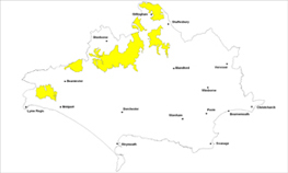
The Clay Vale landscape type is found in a broken sweep across the north western parts of the county beyond the western and northern edges of the chalk escarpment.
Key Characteristics
- flat to gently undulating or bowl shaped clay landform.
- flanked and defined by surrounding limestone, chalk and/or greensand hills and ridges.
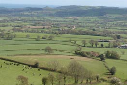
- a homogenous grassland landscape with a patchwork of small to medium sized fields, woods or ribbons of trees and dense trimmed hedgerows.
- distinctive mature hedgerow oaks dot the landscape in a distinctive pattern.
- long tradition of dairy farming.
- dense network of twisting narrow lanes lined by thick hedgerows.
- evenly scattered hamlets, small villages and farmsteads often associated with groups of trees.
- many small streams and watercourses often lined with ribbons of trees.
- ponds are a key feature within the vale and many are important for protected species especially great crested newts.
- a peaceful, undeveloped and secluded rural atmosphere.
The Clay Vale landscape is divided into distinct areas by either limestone, chalk and/or greensand ridges or hills and it extends north into Wiltshire and Somerset. It is represented in the west by the intimate bowl shaped Marshwood Vale and the smaller Halstock Vale and in north Dorset by the broader scale landscape of the Blackmore Vale, which is drained by the River Stour. It is very much a homogenous grassland landscape characterised by predominantly small pastoral fields with dense trimmed hedgerows, small woods or ribbons of trees and distinctive mature hedgerow oaks, which together combine to create a distinctive ‘fine grained’ consistent patchwork landscape. Many of these distinctive oaks are becoming ‘stag headed’ with age. There are patterns of medieval settlement and clearance and the areas have a long tradition of dairy farming. There are often open views across the undulating to flat pastoral landscape to the chalk, limestone or greensand hills and ridges, which enclose and define this landscape. The network of hedgelined twisting lanes and scattered farmsteads, hamlets and picturesque villages such as Halstock, Leigh and Milton on Stour, underpin the largely undeveloped, harmonious and tranquil character. Many of the small copses and woods are associated with these small hamlets, villages and farmsteads or are found as ribbons following the many small stream corridors. It is in this later situation that old pollards are found.
Management Objectives
The overall management objective for the Clay Vale Landscape Type is to conserve the patterns that contribute to the rural, tranquil landscape of winding lanes and small-scattered settlements. Restoration of the elements, which are in decline such as the hedgerows, hedgerow trees and narrow corridors of wet woodlands is also a key objective.
Key land management guidance notes
- encourage maintenance and enhancement of boundaries, particularly along the vale and replant any gaps where necessary.
- plant new hedgerow oaks at regular intervals to replace existing mature stock.
- protect, restore and create new field ponds
- restore streamside habitats and wet woodlands and consider extending wet woodland, particularly around existing settlements and farmsteads.
- conserve and enhance management of neutral unimproved meadows and encourage restoration where appropriate.
- restore and manage pollard trees.
- protect the consistent pattern of regular enclosures and surviving strip and open fields.
- restore remaining coppice woodlands around the vale edge.
- conserve the pattern and character of small settlements and associated surrounding trees/copses/woodlands.
- conserve ponds which must also be properly assessed for protected species prior to determining any application for development
- identify, protect and conserve the long ranging views especially from roads, Rights of Way and key viewpoints to surrounding hills and ridges e.g. via Parish Action Plans, Village Design Statements and other Settlement Appraisals.
