Undulating river valley


Location
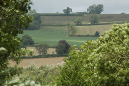
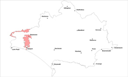
The Undulating River Valley landscape type is based on the river valleys of the Brit and Axe.
Key Characteristics
- meandering flat river floodplains with rolling adjacent hills.
- patchwork of small fields on the valley floor and a mix of arable and pasture elsewhere with trimmed hedgerows.
- occasional woods along the valley sides.
- historic bridging points.
- extensive grazing marsh and reedbeds towards the coast.
- scattered clustered settlements with golden limestone and thatch.
- occasional orchards.
- ribbons of wet woods and tree groups along watercourses.
- important parkland landscapes.
- open views along valley bottoms.
The Undulating River Valley landscape is based on the alluvial floodplains of the above two rivers and the associated surrounding branching valleys and undulating/rolling hills. It has a diverse character ranging from open rolling countryside to market towns such as Bridport and Beaminster and clustered villages dotted along the upper terraces, such as at Drimpton and Netherbury and along the valley floor, for example at Mosterton. Many of the small settlements use locally distinctive golden limestone and thatch. The Axe meanders along the border with Somerset and has a broad undulating valley with flatter fields adjacent to the river. There are no roads along the valley but many river crossings points.
Management Objectives
The overall management objective for the Undulating River Valley Landscape Type should be to conserve the open floodplains, wet woodlands and damp meadows together with enhancement and restoration of hedgerows and hedgerow trees. The protection of the surrounding open rural countryside from further intrusive development is also a key objective.
Key land management guidance notes
- conserve the ancient pattern of small irregular pastoral fields and narrow lanes interspersed with irregular patches of woodland.
- replant hedgerow sections where historical loss has taken place and plant new hedgerow trees.
- enhance woodland management,particularly coppice woodlands with small scale planting of broad leaves along valley sides. Protect the character of important open skylines from future planting.
- ensure conservation of low impact grassland.
- remove non native poplars in open locations in a phased programme.
- promote restoration of orchards and parkland landscapes.
- encourage maintenance of species rich hedgerows, particularly along the valley floors and replant any gaps where necessary.
- protect watercourses and associated wildlife from soil erosion and the effects of diffuse pollution,through creation of buffers allowing semi natural habitats to develop,including scrub and wet woodland.
- consider screening views to intrusive agricultural buildings and settlement edges through planting new small-scale broad leaved woodlands.
- where appropriate, encourage the planting of small scale native woodlands to reduce the visual impact of the urban area and in particular existing commercial/ industrial uses.
- take an integrated approach to increase access to the countryside, promote nature conservation and green space provision around urban areas.
